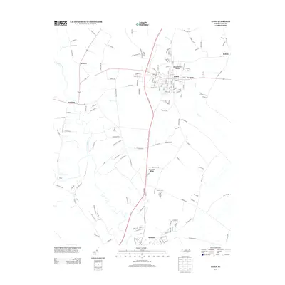
2013 Map of Ayden
USGS Topo · Published 2013About this map
Ayden stands as a central hub in this corner of Pitt County, where a dense network of residential streets and local landmarks like Strawberry Banks and Deerfield define the town's modern footprint. The landscape is shaped significantly by the winding course of Little Contentnea Cr to the west and Swift Cr to the east, which frame the agricultural and residential transition between larger settlements and rural clusters. To the south, the map reaches the northern edges of Grifton, connected to the rest of the quadrangle by North Carolina Highway 11. Historically significant locales such as Scuffleton, Rountree, and Hanrahan are documented here, alongside established neighborhoods like The Pines. The road network, including family-named routes like Ernest Loftin Rd and Marvin Taylor Rd, reveals the enduring rural character and lineage of the land surrounding the more developed town centers.
Find a feature on this map
154 named features on this map. Tap any name to fly to it.
Don’t see what you’re looking for? This feature index may not catch every label — zoom into the map to look around manually.
Map Details
Editions of this 2013 Ayden Map
This is the sole edition of this map. No revisions or reprints were ever made.
Other maps of this area

1902 · Ayden
USGS Topo · 1:62,500

1903 · Winterville
USGS Topo · 1:62,500

1904 · Ayden
USGS Topo · 1:62,500

1904 · Falkland
USGS Topo · 1:62,500

1905 · Winterville
USGS Topo · 1:62,500

1914 · Kinston
USGS Topo · 1:48,000

1916 · Kinston
USGS Topo · 1:62,500

1953 · Rocky Mount
USGS Topo · 1:250,000

1954 · Rocky Mount
USGS Topo · 1:250,000
1981 · Farmville
USGS Topo · 1:24,000