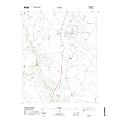
2019 Map of Ayden
USGS Topo · Published 2019About this map
Contentnea Creek and its tributary, Little Contentnea Creek, define the low-lying landscape of southern Pitt County in this 2019 survey. The town of Ayden serves as the central hub, surrounded by smaller agrarian communities such as Littlefield, Hanrahan, and Scuffleton. The map documents a blend of established townships and quiet crossroads, where large wetland areas like those along Swift Cr meet the expanding outskirts of Winterville to the north. For those researching family history in the region, the placement of the Artis Cem and Jackson Cem offers precise locations for ancestral study. The transition from the rural roads of Rountree to the municipal grid of Grifton illustrates the persistent balance between the agricultural roots and modern development of these North Carolina plains.
Find a feature on this map
121 named features on this map. Tap any name to fly to it.
Don’t see what you’re looking for? This feature index may not catch every label — zoom into the map to look around manually.
Map Details
Editions of this 2019 Ayden Map
This is the sole edition of this map. No revisions or reprints were ever made.
Other maps of this area

1902 · Ayden
USGS Topo · 1:62,500

1903 · Winterville
USGS Topo · 1:62,500

1904 · Ayden
USGS Topo · 1:62,500

1904 · Falkland
USGS Topo · 1:62,500

1905 · Winterville
USGS Topo · 1:62,500

1914 · Kinston
USGS Topo · 1:48,000

1916 · Kinston
USGS Topo · 1:62,500

1953 · Rocky Mount
USGS Topo · 1:250,000

1954 · Rocky Mount
USGS Topo · 1:250,000
1981 · Farmville
USGS Topo · 1:24,000