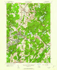
1950 Map of Ayer
USGS Topo · Published 1958About this map
Fort Devens Mil Res dominates the southwestern quadrant of this study, revealing the dense infrastructure of the military installation including its Fort Devens Airport, Rifle Range, and Filtration Beds. The map illustrates a complex landscape where institutional land use and traditional New England village patterns meet. Academic and scientific sites are prominent, from the historic Lawrence Academy and Groton School in Groton to the Harvard University Observatory located on a ridge in the south. The convergence of the Boston and Maine Railroad and the Fitchburg and Main Railroad at Ayer underscores the area's importance as a regional transportation hub. To the east, the landscape transitions into a series of interconnected water bodies such as Knops Pond and Spectacle Pond, alongside the unique historic site of Shaker Village.
Find a feature on this map
81 named features on this map. Tap any name to fly to it.
Don’t see what you’re looking for? This feature index may not catch every label — zoom into the map to look around manually.
Map Details
Editions of this 1950 Ayer Map
This is the sole edition of this map. No revisions or reprints were ever made.
Other maps of this area

1886 · Lowell
USGS Topo · 1:62,500

1886 · Framingham
USGS Topo · 1:62,500

1887 · Marlboro
USGS Topo · 1:62,500

1889 · Marlboro
USGS Topo · 1:62,500

1889 · Framingham
USGS Topo · 1:62,500

1893 · Lowell
USGS Topo · 1:62,500

1893 · Groton
USGS Topo · 1:62,500

1894 · Framingham
USGS Topo · 1:62,500

1896 · Marlboro
USGS Topo · 1:62,500

1898 · Marlboro
USGS Topo · 1:62,500