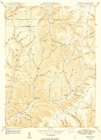
1949 Map of Ayers Hill
USGS Topo · Published 1949About this map
Deep ravines and high ridges define the landscape of Potter County in the late 1940s, where small settlements like Ayers Hill and Borie occupy the narrow gaps between steep upland summits. The map illustrates a rural society organized around its waters, from the headwaters of Sinnemahoning Creek First Fork to the winding course of Prouty Run. Local heritage is preserved in sites like the United Brethren Ch and several family-named burial grounds, including Ayers Hill Cem and Jackson Cem.
Find a feature on this map
75 named features on this map. Tap any name to fly to it.
Don’t see what you’re looking for? This feature index may not catch every label — zoom into the map to look around manually.
Map Details
Editions of this 1949 Ayers Hill Map
2 editions found
Other maps of this area

1932 · Genesee
USGS Topo · 1:62,500

1934 · Coudersport
USGS Topo · 1:48,000

1937 · Genesee
USGS Topo · 1:62,500

1938 · Coudersport
USGS Topo · 1:62,500

1947 · Conrad
USGS Topo · 1:62,500

1947 · Conrad
USGS Topo · 1:24,000

1947 · Short Run
USGS Topo · 1:24,000

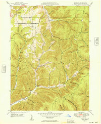
1947 · Ayers Hill
USGS Topo · 1:24,000

1947 · Cherry Springs
USGS Topo · 1:24,000

1948 · Emporium
USGS Topo · 1:62,500
Featured Places
- Sweden Township, PA
- Borie, Summit Township
- Summit Township, PA
- Sylvania Township, PA
- Eulalia Township, PA