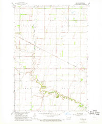
1967 Map of Ayr SE
USGS Topo · Published 1969About this map
Rush River meanders through this agricultural landscape in Cass County, forming a serpentine corridor across the townships of Erie, Arthur, Empire, and Amenia. This 1967 survey illustrates a classic Red River Valley rail-and-farm economy, where the Great Northern railroad cuts a straight diagonal through the terrain, serving the small settlement of Mason. This transportation network is essential to the region's grain-production heritage, linking isolated farmsteads to larger markets.
Find a feature on this map
10 named features on this map. Tap any name to fly to it.
Don’t see what you’re looking for? This feature index may not catch every label — zoom into the map to look around manually.
Map Details
Editions of this 1967 Ayr SE Map
This is the sole edition of this map. No revisions or reprints were ever made.
Other maps of this area

1895 · Casselton
USGS Topo · 1:125,000

1897 · Casselton
USGS Topo · 1:125,000

1952 · Grand Forks
USGS Topo · 1:250,000

1953 · Fargo
USGS Topo · 1:250,000

1956 · Fargo
USGS Topo · 1:250,000

1956 · Grand Forks
USGS Topo · 1:250,000

1961 · Casselton
USGS Topo · 1:24,000

1966 · Grand Forks
USGS Topo · 1:250,000

1967 · Ayr NE
USGS Topo · 1:24,000

1967 · Ayr NW
USGS Topo · 1:24,000