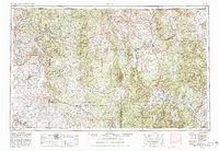
1954 Map of Aztec
USGS Topo · Published 1982About this map
The Continental Divide winds through this high-altitude landscape, defining the watershed where the San Juan River and Rio Chama systems diverge. The mid-20th-century topography reveals a vast expanse of tribal and federal lands, dominated by the Jicarilla Apache Indian Reservation and the sprawling Carson National Forest. Settled life follows the narrow river valleys, anchored by communities like Tierra Amarilla, Bloomfield, and the isolated village of Monero. In the north, the narrow-gauge path of the Denver & Rio Grande Western RR cuts through the mountains near Lumberton and Dulce, serving as a vital transportation artery before the era of modern highway dominance. The mapping reflects a period of significant water management, showing major impoundments such as the Navajo Reservoir and El Vado Reservoir, which transformed the region's hydrology for downstream agriculture and energy. To the south, the preservation of ancient history is marked at Chaco Canyon National Monument, while the San Pedro Peaks stand as prominent landmarks in the southern forests.
Find a feature on this map
127 named features on this map. Tap any name to fly to it.
Don’t see what you’re looking for? This feature index may not catch every label — zoom into the map to look around manually.
Map Details
Editions of this 1954 Aztec Map
4 editions found

Other maps of this area

1883 · Mt. Taylor
USGS Topo · 1:250,000

1886 · Wingate
USGS Topo · 1:250,000

1886 · Mt. Taylor
USGS Topo · 1:250,000

1889 · Largo
USGS Topo · 1:250,000

1889 · Chaco
USGS Topo · 1:250,000

1889 · Santa Fe
USGS Topo · 1:125,000

1890 · Jemes
USGS Topo · 1:125,000

1892 · Jemes
USGS Topo · 1:125,000

1892 · Santa Clara
USGS Topo · 1:125,000

1892 · Wingate
USGS Topo · 1:250,000