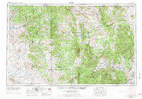
1954 Map of Aztec
USGS Topo · Published 1975About this map
The San Juan River and Rio Chama systems anchor this mid-century look at the high country of northern New Mexico and southern Colorado. The map documents a landscape of significant cultural and federal land management, dominated by the Jicarilla Apache Indian Reservation and sprawling sections of the Carson National Forest and Santa Fe National Forest. In the west, the community of Aztec serves as a hub near the Chaco Canyon National Monument, while to the east, the D & R G W RR winds through the mountains near Monero and Lumberton. Settlement patterns follow the river valleys, with clusters of small communities like Tierra Amarilla, Los Ojos, and Abiquiu situated along the vital waterways of the Rio Brazos and Rio Nutrias. The presence of several remote outposts, such as the Blanco Trading Post and Escavada Trading Post, underscores the area's history of isolated commerce and trade.
Find a feature on this map
110 named features on this map. Tap any name to fly to it.
Don’t see what you’re looking for? This feature index may not catch every label — zoom into the map to look around manually.
Map Details
Editions of this 1954 Aztec Map
4 editions found

Other maps of this area

1883 · Mt. Taylor
USGS Topo · 1:250,000

1886 · Wingate
USGS Topo · 1:250,000

1886 · Mt. Taylor
USGS Topo · 1:250,000

1889 · Largo
USGS Topo · 1:250,000

1889 · Chaco
USGS Topo · 1:250,000

1889 · Santa Fe
USGS Topo · 1:125,000

1890 · Jemes
USGS Topo · 1:125,000

1892 · Jemes
USGS Topo · 1:125,000

1892 · Santa Clara
USGS Topo · 1:125,000

1892 · Wingate
USGS Topo · 1:250,000