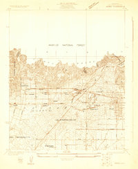
1925 Map of Azusa
USGS Topo · Published 1925About this map
The Sierra Madre mountains loom over the developing San Gabriel Valley floor in this mid-1920s survey. This era captures the region at a transitional moment, where citrus groves and rural tracts meet an expanding industrial and transportation network. The rail systems are particularly prominent, showing the Pacific Electric, Southern Pacific, and Atchison Topeka and Santa Fe lines intersecting near the San Gabriel River.
Find a feature on this map
33 named features on this map. Tap any name to fly to it.
Don’t see what you’re looking for? This feature index may not catch every label — zoom into the map to look around manually.
Map Details
Editions of this 1925 Azusa Map
This is the sole edition of this map. No revisions or reprints were ever made.
Other maps of this area

1894 · Los Angeles
USGS Topo · 1:62,500

1894 · Pomona
USGS Topo · 1:62,500

1896 · Pasadena
USGS Topo · 1:62,500

1897 · Pomona
USGS Topo · 1:62,500

1898 · Pomona
USGS Topo · 1:62,500

1900 · Pasadena
USGS Topo · 1:62,500

1900 · Los Angeles
USGS Topo · 1:62,500

1901 · Southern California Sheet No. 1
USGS Topo · 1:250,000

1904 · Pomona
USGS Topo · 1:62,500

1904 · Southern California Sheet No. 1
USGS Topo · 1:250,000