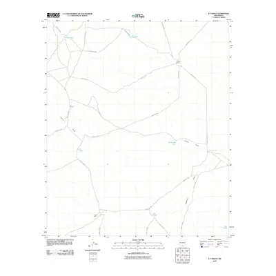
2010 Map of B T Ranch
USGS Topo · Published 2010About this map
B T Ranch and Wimberly Ranch anchor this arid Otero County landscape, where survival is historically tied to seasonal water management. The terrain is defined by wide drainage systems including Shiloh Draw and Hackberry Draw, which are supplemented by a network of man-made catchments. These water features, ranging from the CCC Tank to the centrally located Jug Tank, speak to the persistence of ranching in a desert environment. A legacy of early 20th-century public works is visible in the naming of the CCC Tank, while other features like Badger Well and Rob Tanks highlight the importance of specific localized water sources for livestock. The area is intersected by a complex web of designated county roads, such as County Rd-F034 and County Rd-F054, which connect these remote operations across the high plains of southern New Mexico.
Find a feature on this map
22 named features on this map. Tap any name to fly to it.
Don’t see what you’re looking for? This feature index may not catch every label — zoom into the map to look around manually.
Map Details
Editions of this 2010 B T Ranch Map
This is the sole edition of this map. No revisions or reprints were ever made.
Other maps of this area

1940 · Bassett Lake
USGS Topo · 1:62,500

1943 · Pendejo Wash
USGS Topo · 1:62,500

1943 · Bassett Lake
USGS Topo · 1:62,500

1954 · Carlsbad
USGS Topo · 1:250,000

1958 · Carlsbad
USGS Topo · 1:250,000

1959 · Alamo Mountain
USGS Topo · 1:62,500
1975 · Alamo Mountain
USGS Topo · 1:24,000

1975 · Alamo Mountain NE
USGS Topo · 1:24,000
1975 · B T Ranch
USGS Topo · 1:24,000
1975 · Cornudas Mountain
USGS Topo · 1:24,000