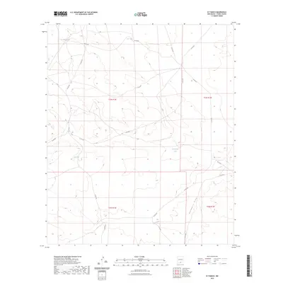
2023 Map of B T Ranch
USGS Topo · Published 2023About this map
Hackberry Draw carves a path through the arid landscape of Otero County in this detailed survey, highlighting the critical role of water management in New Mexico's ranching country. The terrain is marked by a network of essential water sources including Potter Tank, CCC Tank, and Brownfield Tank, which serve as vital landmarks across the survey townships of t24s r12e and t25s r13e. The distribution of these tanks alongside roads like Co Rd F034 and Co Rd F056 reveals the infrastructure required to sustain life and livestock in this high-desert environment. The map provides a precise look at the township and range boundaries that define property and land use in this sparsely populated region.
Find a feature on this map
22 named features on this map. Tap any name to fly to it.
Don’t see what you’re looking for? This feature index may not catch every label — zoom into the map to look around manually.
Map Details
Editions of this 2023 B T Ranch Map
This is the sole edition of this map. No revisions or reprints were ever made.
Other maps of this area

1940 · Bassett Lake
USGS Topo · 1:62,500

1943 · Pendejo Wash
USGS Topo · 1:62,500

1943 · Bassett Lake
USGS Topo · 1:62,500

1954 · Carlsbad
USGS Topo · 1:250,000

1958 · Carlsbad
USGS Topo · 1:250,000

1959 · Alamo Mountain
USGS Topo · 1:62,500
1975 · Alamo Mountain
USGS Topo · 1:24,000

1975 · Alamo Mountain NE
USGS Topo · 1:24,000
1975 · B T Ranch
USGS Topo · 1:24,000
1975 · Cornudas Mountain
USGS Topo · 1:24,000