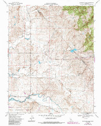
1968 Map of Bachelor Valley
USGS Topo · Published 1987About this map
Bachelor Valley is defined by a complex network of seasonal drainages and early ranching foundations along the Calaveras and Stanislaus county line. The landscape is shaped by water management and transit, anchored by the Farmington Flood Control Basin and the meandering path of Littlejohns Creek. Significant local history is preserved in the presence of the St Joseph Cem and the Rosedale Sch near the settlement of Eugene, providing specific points of interest for genealogists tracing early residents of this rural corridor. Historically partitioned land is evident in the Sonora Rancheria Del Rio Estanislao and the Eight Square Leagues on Stanislaus River boundaries. From the high ground at Black Hill down to the working lands of Snow Ranch, the map illustrates a transition from wild gulches to managed floodplains.
Find a feature on this map
29 named features on this map. Tap any name to fly to it.
Don’t see what you’re looking for? This feature index may not catch every label — zoom into the map to look around manually.
Map Details
Editions of this 1968 Bachelor Valley Map
3 editions found
Other maps of this area

1889 · Jackson
USGS Topo · 1:125,000

1892 · Jackson
USGS Topo · 1:125,000

1897 · Jackson
USGS Topo · 1:125,000

1902 · Jackson
USGS Topo · 1:125,000

1915 · Oakdale
USGS Topo · 1:31,680

1915 · Trigo
USGS Topo · 1:31,680

1915 · Thalheim
USGS Topo · 1:31,680

1916 · Bachelor Valley
USGS Topo · 1:31,680

1916 · Copperopolis
USGS Topo · 1:62,500

1942 · Farmington
USGS Topo · 1:62,500