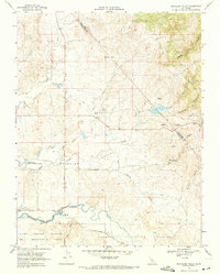
1968 Map of Bachelor Valley
USGS Topo · Published 1971About this map
Bachelor Valley and the surrounding rangelands of the Calaveras and Stanislaus county border are defined by a complex network of seasonal drainages and early California land grants. This 1968 field-checked map illustrates the cattle-ranching character of the region, featuring named operations such as Snow Ranch and Bund Ranch situated amongst the dry gulches. The small settlement of Eugene serves as a focal point in the southern portion of the quadrangle, where the Rosedale School and St Joseph Cemetery stand near the banks of Littlejohns Creek. Significant land use planning is evident in the Farmington Flood Control Basin, which occupies a broad section of the low-lying terrain. The map also preserves the boundaries of the historic Eight Square Leagues and Rancheria Del Rio Estanislao grants, reflecting the deep-rooted colonial and Mexican-era land tenure systems that shaped this part of the Central Valley foothills.
Find a feature on this map
29 named features on this map. Tap any name to fly to it.
Don’t see what you’re looking for? This feature index may not catch every label — zoom into the map to look around manually.
Map Details
Editions of this 1968 Bachelor Valley Map
3 editions found
Other maps of this area

1889 · Jackson
USGS Topo · 1:125,000

1892 · Jackson
USGS Topo · 1:125,000

1897 · Jackson
USGS Topo · 1:125,000

1902 · Jackson
USGS Topo · 1:125,000

1915 · Oakdale
USGS Topo · 1:31,680

1915 · Trigo
USGS Topo · 1:31,680

1915 · Thalheim
USGS Topo · 1:31,680

1916 · Bachelor Valley
USGS Topo · 1:31,680

1916 · Copperopolis
USGS Topo · 1:62,500

1942 · Farmington
USGS Topo · 1:62,500