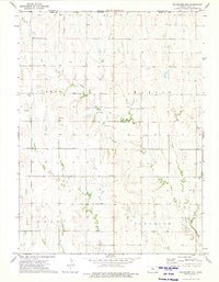
1973 Map of Bachelors Run
USGS Topo · Published 1975About this map
Middle Beaver Creek and its various tributaries, including West Beaver Creek and the namesake Bachelors Run, dominate the drainage patterns of this Kansas landscape. Situated along the boundary between Franklin and Smith Counties, the area is divided into several rural townships, including German, Martin, Swan, and Pleasant. The terrain is primarily agricultural, punctuated by small-scale industrial activity such as a Quarry located near the center of the sheet and another to the northeast. Historical and genealogical interest is centered on the Pleasant Hill Cem located in Martin Township, serving as a focal point for the surrounding farmsteads. The lack of concentrated urban development highlights a mid-1970s environment defined by section-line roads and dispersed rural infrastructure, such as the Radio Tower in the western section of the map.
Find a feature on this map
13 named features on this map. Tap any name to fly to it.
Don’t see what you’re looking for? This feature index may not catch every label — zoom into the map to look around manually.
Map Details
Editions of this 1973 Bachelors Run Map
This is the sole edition of this map. No revisions or reprints were ever made.
Other maps of this area

1893 · Smith Center
USGS Topo · 1:125,000

1893 · Phillipsburg
USGS Topo · 1:125,000

1896 · Holdrege
USGS Topo · 1:125,000

1897 · Red Cloud
USGS Topo · 1:125,000

1955 · Grand Island
USGS Topo · 1:250,000

1955 · Beloit
USGS Topo · 1:250,000

1957 · Grand Island
USGS Topo · 1:250,000

1958 · Grand Island
USGS Topo · 1:250,000

1959 · Beloit
USGS Topo · 1:250,000

1973 · Kensington
USGS Topo · 1:24,000