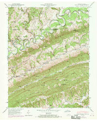
1946 Map of Back Valley
USGS Topo · Published 1970About this map
The Powell River meanders sharply through the ridge-and-valley landscape of this 1946 survey, later updated with 1969 aerial data. This terrain is defined by the steep parallel rises of Wallen Ridge, Powell Mountain, and Snake Mountain, which confine settlement to the narrow corridors of Back Valley and the banks of Blackwater Creek. Local industry and community life are grounded in the topography, evidenced by Thompson Mill on the river and Mathis Mill near Brier Creek. Genealogists will find a dense network of country institutions, from the Wolfenbarger Cem and Sandy Springs Ch to rural schoolhouses like Ramsey Sch and Beech Grove Sch. These landmarks, along with river crossings like Baldwin Ford and Bartley Ford, illustrate the persistent rural character of the Tennessee-Virginia borderlands before modern consolidation.
Find a feature on this map
63 named features on this map. Tap any name to fly to it.
Don’t see what you’re looking for? This feature index may not catch every label — zoom into the map to look around manually.
Map Details
Editions of this 1946 Back Valley Map
2 editions found
Other maps of this area

1883 · Morristown
USGS Topo · 1:125,000

1887 · Jonesville
USGS Topo · 1:125,000

1891 · Jonesville
USGS Topo · 1:125,000

1893 · Morristown
USGS Topo · 1:125,000

1895 · Morristown
USGS Topo · 1:125,000

1932 · Hagan
USGS Topo · 1:62,500
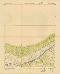
1935 · Ewing
USGS Topo · 1:24,000

1935 · Rogersville
USGS Topo · 1:48,000

1935 · Tate Springs
USGS Topo · 1:48,000

1935 · Lee Valley
USGS Topo · 1:24,000