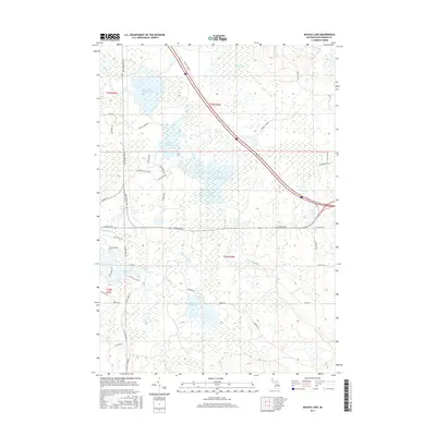
2017 Map of Backus Lake
USGS Topo · Published 2017About this map
The low-lying wetlands of Vinemile Hill Swamp and the headwaters of the Denton Cr system characterize this portion of Roscommon County. This landscape is defined by extensive managed water levels, including the Little Mud Lake-Flooding and the broad reach of Backus Lake Flooding. These interconnected basins reveal a complex hydraulic network where Backus Cr and Spring Brook drain toward the larger lakes. Residential development is concentrated in the southwest corner around the shores of Lake James and Shadow Lake, where a dense network of local roads like Driftwood Cir and E Shadow Lake Rd contrasts with the wilder, marshy areas to the north. Local landmarks such as Ryan Lake and the crossing of E Russell Lake Rd provide essential reference points for this damp, forested terrain.
Find a feature on this map
47 named features on this map. Tap any name to fly to it.
Don’t see what you’re looking for? This feature index may not catch every label — zoom into the map to look around manually.
Map Details
Editions of this 2017 Backus Lake Map
This is the sole edition of this map. No revisions or reprints were ever made.
Other maps of this area

1954 · Traverse City
USGS Topo · 1:250,000

1958 · Traverse City
USGS Topo · 1:250,000

1963 · Roscommon South
USGS Topo · 1:24,000

1963 · Backus Lake
USGS Topo · 1:24,000

1963 · Prudenville
USGS Topo · 1:24,000
1963 · Lyon Manor
USGS Topo · 1:24,000

1965 · St. Helen NW
USGS Topo · 1:24,000

1965 · St. Helen
USGS Topo · 1:24,000

1969 · Meredith NW
USGS Topo · 1:24,000

1969 · Meredith
USGS Topo · 1:24,000