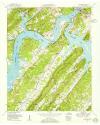
1952 Map of Bacon Gap
USGS Topo · Published 1955About this map
The Clinch River and Tennessee River converge at Southwest Point, marking a historical junction that defines the geography of Kingston. Following the 1952 revision by the Tennessee Valley Authority, this map shows the significant impact of the Watts Bar Lake impoundment, which flooded lower elevations and created numerous inlets along Caney Creek and Bullet Branch. The terrain is dominated by the linear ridges of the River Knobs and Bacon Ridge, where many family cemeteries, such as Bowman Cemetery and Barnard Cemetery, are situated on higher ground above the new waterline.
Find a feature on this map
71 named features on this map. Tap any name to fly to it.
Don’t see what you’re looking for? This feature index may not catch every label — zoom into the map to look around manually.
Map Details
Editions of this 1952 Bacon Gap Map
This is the sole edition of this map. No revisions or reprints were ever made.
Other maps of this area

1887 · Kingston
USGS Topo · 1:125,000

1891 · Kingston
USGS Topo · 1:125,000

1893 · Kingston
USGS Topo · 1:125,000

1895 · Loudon
USGS Topo · 1:125,000

1935 · Rockwood
USGS Topo · 1:24,000

1935 · Elverton
USGS Topo · 1:24,000

1935 · Harriman
USGS Topo · 1:24,000

1935 · Philadelphia
USGS Topo · 1:24,000

1936 · Cave Creek
USGS Topo · 1:24,000

1936 · Cardiff
USGS Topo · 1:24,000