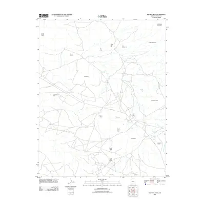
2011 Map of Bad Bug Butte
USGS Topo · Published 2011About this map
Lukachukai Mountains and the Chuska Mountains dominate the horizon of this northern Arizona landscape, where a network of unpaved tribal routes connects isolated settlements. The area around Bad Bug Butte is characterized by dramatic landforms, including Sitting Coyote Mesa and the tapering Tall Cone at the southern edge. Human activity is centered on scattered locales like Toohidazdii, Bijaadibae, and Tahdahatooc, supported by critical desert resources such as Cool Water Spring. Transportation in the region relies on Indian Rte-12 and Indian Rte-8087, which provide access to the Lukachukai Airport near Greasewood Wash. This modern survey illustrates how traditional travel corridors continue to serve the high mesa country, following natural drainage patterns like Tohotso Creek.
Find a feature on this map
26 named features on this map. Tap any name to fly to it.
Don’t see what you’re looking for? This feature index may not catch every label — zoom into the map to look around manually.
Map Details
Editions of this 2011 Bad Bug Butte Map
This is the sole edition of this map. No revisions or reprints were ever made.
Other maps of this area

1892 · Canyon De Chelly
USGS Topo · 1:250,000

1953 · Redrock Valley SW
USGS Topo · 1:24,000

1953 · Los Gigantes SE
USGS Topo · 1:24,000

1953 · Los Gigantes SW
USGS Topo · 1:24,000

1953 · Los Gigantes Buttes
USGS Topo · 1:62,500

1953 · Redrock Valley
USGS Topo · 1:62,500

1954 · Shiprock
USGS Topo · 1:250,000
1955 · Sonsala Butte 1 NW
USGS Topo · 1:24,000

1955 · Sonsala Butte 2 SW
USGS Topo · 1:24,000

1955 · Sonsala Butte 2 NW
USGS Topo · 1:24,000