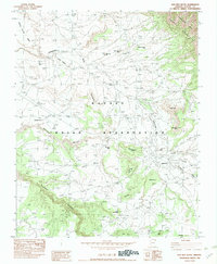
1982 Map of Bad Bug Butte
USGS Topo · Published 1982About this map
Navajo Indian Reservation lands within the Chuska Mountains define this 1982 survey, which documents a landscape of dramatic sandstone formations and high-altitude mesas. The terrain is deeply incised by drainages such as Bihilinie Canyon and Tsedatoh Canyon, which feed into the primary arterial watercourses of Lukachukai Wash and Toonidazdi Wash. Small settlements like Rough Rock and Lukachukai are shown in relation to their surrounding landmarks, including the namesake Bad Bug Butte and the curiously named The Legs. The map illustrates the practical infrastructure of the high desert in the early 1980s, noting the Landing Strip (Dirt) and several improved roads connecting these remote communities. For the researcher, the map preserves specific local nomenclature for high points and mesas such as Sitting Coyote Mesa, Bijaadibae, and The Pillow.
Find a feature on this map
32 named features on this map. Tap any name to fly to it.
Don’t see what you’re looking for? This feature index may not catch every label — zoom into the map to look around manually.
Map Details
Editions of this 1982 Bad Bug Butte Map
This is the sole edition of this map. No revisions or reprints were ever made.
Other maps of this area

1892 · Canyon De Chelly
USGS Topo · 1:250,000

1953 · Redrock Valley SW
USGS Topo · 1:24,000

1953 · Los Gigantes SE
USGS Topo · 1:24,000

1953 · Los Gigantes SW
USGS Topo · 1:24,000

1953 · Los Gigantes Buttes
USGS Topo · 1:62,500

1953 · Redrock Valley
USGS Topo · 1:62,500

1954 · Shiprock
USGS Topo · 1:250,000
1955 · Sonsala Butte 1 NW
USGS Topo · 1:24,000

1955 · Sonsala Butte 2 SW
USGS Topo · 1:24,000

1955 · Sonsala Butte 2 NW
USGS Topo · 1:24,000