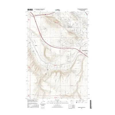
2017 Map of Badger Mountain
USGS Topo · Published 2017About this map
Badger Mtn and the northern slopes of the Horse Heaven Hills dominate this survey of the growing Tri-Cities region. The urban expansion of Richland and Kennewick is evident in the dense residential street grids pushing toward the foothills, contrasted against the older agricultural infrastructure of the Columbia Canal and the E Badger Lateral. This landscape is defined by its transition from the irrigated valley floor near the Yakima River to the prominent ridges and canyons of the upland. Significant recreational and natural corridors are marked, including the Skyline Trail crossing the mountain and the Amon Creek Nature Trail winding through the southeastern neighborhoods. Small geographic landmarks like Goose Gap and Badger Spring sit alongside deep-cut terrain features such as Sheep Canyon and Scouten Canyon, showing the complex topography that shapes local development.
Find a feature on this map
160 named features on this map. Tap any name to fly to it.
Don’t see what you’re looking for? This feature index may not catch every label — zoom into the map to look around manually.
Map Details
Editions of this 2017 Badger Mountain Map
This is the sole edition of this map. No revisions or reprints were ever made.
Other maps of this area

1917 · Pasco
USGS Topo · 1:125,000

1951 · Richland
USGS Topo · 1:62,500

1953 · Walla Walla
USGS Topo · 1:250,000

1958 · Walla Walla
USGS Topo · 1:250,000
1964 · Johnson Butte
USGS Topo · 1:24,000

1964 · Kennewick
USGS Topo · 1:24,000

1964 · Pasco
USGS Topo · 1:62,500
1965 · Prior Ranch
USGS Topo · 1:24,000

1965 · Eltopia
USGS Topo · 1:62,500
1965 · Weber Canyon
USGS Topo · 1:24,000