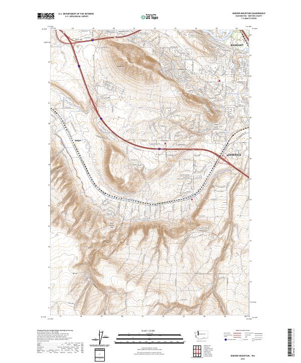
2023 Map of Badger Mountain
USGS Topo · Published 2023About this map
Badger Mtn rises above the expanding suburban landscapes of Richland and Kennewick, anchoring a terrain defined by complex water management and the northern edge of the Horse Heaven Hills. The map details an intricate network of irrigation systems essential to this arid region, including the Columbia Canal, Kennewick Main Canal, and both the East Badger Lateral and West Badger Lateral. These waterways trace the contours of the land, supporting a transition from the riparian environment of the Yakima River to the upland slopes of Goose Gap. From the residential developments near Meadow Springs Reservoir to the more open reaches of Badger Canyon and Scouten Canyon, the survey documents the intersection of modern infrastructure with natural landmarks like Badger Spring and Coyote Spring.
Find a feature on this map
172 named features on this map. Tap any name to fly to it.
Don’t see what you’re looking for? This feature index may not catch every label — zoom into the map to look around manually.
Map Details
Editions of this 2023 Badger Mountain Map
This is the sole edition of this map. No revisions or reprints were ever made.
Other maps of this area

1917 · Pasco
USGS Topo · 1:125,000

1951 · Richland
USGS Topo · 1:62,500

1953 · Walla Walla
USGS Topo · 1:250,000

1958 · Walla Walla
USGS Topo · 1:250,000
1964 · Johnson Butte
USGS Topo · 1:24,000

1964 · Kennewick
USGS Topo · 1:24,000

1964 · Pasco
USGS Topo · 1:62,500
1965 · Prior Ranch
USGS Topo · 1:24,000

1965 · Eltopia
USGS Topo · 1:62,500
1965 · Weber Canyon
USGS Topo · 1:24,000