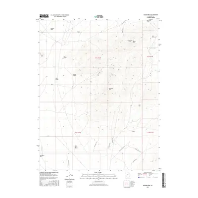
2017 Map of Badger Peak
USGS Topo · Published 2017About this map
The Black Mountains and the eastern margins of the Escalante Desert define this high-altitude landscape in Iron County. Dominating the topography is the massive rise of Badger Peak and the adjacent Hot Springs Peaks, where narrow drainages like Wood Canyon and First Canyon cut through the volcanic terrain. The map details a network of early infrastructure and primitive roads essential for desert navigation, including the historic alignment of the Old Telephone Pole Line and routes like Lost Spring Rd. To the south, the terrain levels out across Mud Spring Bench and the narrow passage of The Neck. This area represents a classic Great Basin transition where isolated water sources, such as the Hot Springs Canyon Pond and Mud Spring Wash, were critical for the early ranching and surveying efforts that shaped southwestern Utah.
Find a feature on this map
32 named features on this map. Tap any name to fly to it.
Don’t see what you’re looking for? This feature index may not catch every label — zoom into the map to look around manually.
Map Details
Editions of this 2017 Badger Peak Map
This is the sole edition of this map. No revisions or reprints were ever made.
Other maps of this area

1885 · St. George
USGS Topo · 1:250,000

1891 · St. George
USGS Topo · 1:250,000

1950 · Enoch
USGS Topo · 1:62,500

1950 · Enoch NE
USGS Topo · 1:24,000

1951 · Avon
USGS Topo · 1:24,000
1952 · Enoch NW
USGS Topo · 1:24,000

1952 · Enoch NE
USGS Topo · 1:24,000

1953 · Ninemile Knoll
USGS Topo · 1:24,000

1953 · Richfield
USGS Topo · 1:250,000

1953 · Cedar City
USGS Topo · 1:250,000