
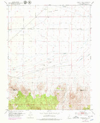
1953 Map of Ninemile Knoll
USGS Topo · Published 1954About this map
The Escalante Desert dominates this 1953 landscape, revealing a high-altitude basin where water management was the primary concern for mid-century surveyors. The map is marked by a complex network of infrastructure, including a prominent Ditch system and an Irrigation Canal that cut across the arid terrain. Natural water features are scarce but critical, such as Cactus Pond, Sand Pond, and the ephemeral drainage known as The Sink.
Find a feature on this map
17 named features on this map. Tap any name to fly to it.
Don’t see what you’re looking for? This feature index may not catch every label — zoom into the map to look around manually.
Map Details
Editions of this 1953 Ninemile Knoll Map
2 editions found
Other maps of this area

1885 · Beaver
USGS Topo · 1:250,000

1953 · Milford Flat
USGS Topo · 1:24,000

1953 · Minersville
USGS Topo · 1:24,000

1953 · Cave Canyon
USGS Topo · 1:24,000

1953 · Richfield
USGS Topo · 1:250,000

1958 · Richfield
USGS Topo · 1:250,000

1958 · Minersville
USGS Topo · 1:62,500

1958 · Thermo
USGS Topo · 1:62,500

1958 · Milford
USGS Topo · 1:62,500

1958 · Adamsville
USGS Topo · 1:62,500