
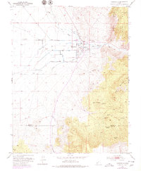
1953 Map of Minersville
USGS Topo · Published 1955About this map
Minersville sits at the eastern edge of the Escalante Valley, where the Beaver River emerges from the high peaks of the Mineral Mts. This mid-century survey documents an intricate irrigation network essential to the high desert, including the Minersville Canal, Low Line Canal, and uniquely named features like The Mile Ditch. The contrast between the flat, canal-fed valley and the surrounding heights is sharp, with Yellow Mountain and Black Mountain rising abruptly to the east. Local landmarks such as Uncle Benneys Orchard and a Cemetery north of town provide specific points of interest for genealogists and local historians. To the south, the landscape transitions into the drainage of Big Wash, while the boundary between Beaver Co and Iron Co cuts across the southern portion of the quadrangle. Small-scale industrial activity is evidenced by a Gravel Pit and scattered Prospects throughout the foothills.
Find a feature on this map
27 named features on this map. Tap any name to fly to it.
Don’t see what you’re looking for? This feature index may not catch every label — zoom into the map to look around manually.
Map Details
Editions of this 1953 Minersville Map
2 editions found
Other maps of this area

1885 · Beaver
USGS Topo · 1:250,000

1953 · Ninemile Knoll
USGS Topo · 1:24,000

1953 · Milford Flat
USGS Topo · 1:24,000

1953 · Cave Canyon
USGS Topo · 1:24,000

1953 · Richfield
USGS Topo · 1:250,000

1958 · Richfield
USGS Topo · 1:250,000

1958 · Minersville
USGS Topo · 1:62,500

1958 · Thermo
USGS Topo · 1:62,500

1958 · Milford
USGS Topo · 1:62,500

1958 · Adamsville
USGS Topo · 1:62,500