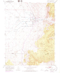
1953 Map of Minersville
USGS Topo · Published 1979About this map
Minersville sits at the nexus of a complex irrigation system in the Utah desert, where the Beaver River is diverted into a network of vital waterways. The town's grid is surrounded by named infrastructure like the Low Line Canal, North Dotson Billins Canal, and the Minersville Ditch, illustrating the intense management of water required to sustain agriculture in this environment. To the east, the landscape rises sharply into the Mineral Mts and Yellow Mountain, while the southern reaches of the map show the border shared by Beaver Co and Iron Co. Notable local landmarks include family-associated features like Uncle Benneys Orchard and a series of vital water sources such as Warm Spr and Little Maple Spring. The presence of several Gravel Pits and various Prospects near the mountains suggests a history tied to both earthworks and mineral exploration.
Find a feature on this map
30 named features on this map. Tap any name to fly to it.
Don’t see what you’re looking for? This feature index may not catch every label — zoom into the map to look around manually.
Map Details
Editions of this 1953 Minersville Map
2 editions found
Other maps of this area

1885 · Beaver
USGS Topo · 1:250,000

1953 · Ninemile Knoll
USGS Topo · 1:24,000

1953 · Milford Flat
USGS Topo · 1:24,000

1953 · Minersville
USGS Topo · 1:24,000

1953 · Cave Canyon
USGS Topo · 1:24,000

1953 · Richfield
USGS Topo · 1:250,000

1958 · Richfield
USGS Topo · 1:250,000

1958 · Minersville
USGS Topo · 1:62,500

1958 · Thermo
USGS Topo · 1:62,500

1958 · Milford
USGS Topo · 1:62,500