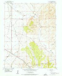
1952 Map of Enoch NW
USGS Topo · Published 1952About this map
The Escalante Desert meets the rugged transitions of the Mud Spring Hills in this 1952 study of Iron County. Water is the primary driver of development and movement in this arid landscape, evidenced by the strategic placement of Norte Well, Stubbs Well, and numerous Windmill sites located along the valley floor. These watering points supported the livestock and ranching activities that defined the local economy during the mid-century era.
Find a feature on this map
13 named features on this map. Tap any name to fly to it.
Don’t see what you’re looking for? This feature index may not catch every label — zoom into the map to look around manually.
Map Details
Editions of this 1952 Enoch NW Map
2 editions found
Other maps of this area

1885 · St. George
USGS Topo · 1:250,000

1891 · St. George
USGS Topo · 1:250,000

1950 · Enoch
USGS Topo · 1:24,000

1950 · Enoch
USGS Topo · 1:62,500

1950 · The Three Peaks
USGS Topo · 1:24,000

1950 · Enoch NE
USGS Topo · 1:24,000

1950 · Avon SE
USGS Topo · 1:24,000

1951 · Avon SE
USGS Topo · 1:24,000
1951 · The Three Peaks
USGS Topo · 1:24,000

1951 · Avon
USGS Topo · 1:24,000