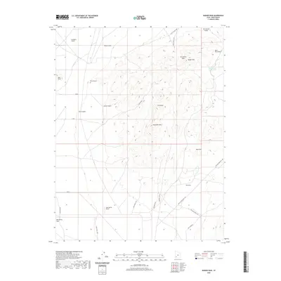
2020 Map of Badger Peak
USGS Topo · Published 2020About this map
The Black Mountains and the eastern fringes of the Escalante Desert define this high-altitude landscape in Iron County. Dominating the central topography is Badger Peak, part of a complex of summits including the Hot Springs Peaks and Twin Peaks. The drainage patterns here are distinct, with water flowing through Wood Canyon, First Canyon, Second Canyon, and Third Canyon toward the desert floor. To the south, The Neck forms a narrow topographical transition near Mule Peak and Monument Peak.
Find a feature on this map
28 named features on this map. Tap any name to fly to it.
Don’t see what you’re looking for? This feature index may not catch every label — zoom into the map to look around manually.
Map Details
Editions of this 2020 Badger Peak Map
This is the sole edition of this map. No revisions or reprints were ever made.
Other maps of this area

1885 · St. George
USGS Topo · 1:250,000

1891 · St. George
USGS Topo · 1:250,000

1950 · Enoch
USGS Topo · 1:62,500

1950 · Enoch NE
USGS Topo · 1:24,000

1951 · Avon
USGS Topo · 1:24,000
1952 · Enoch NW
USGS Topo · 1:24,000

1952 · Enoch NE
USGS Topo · 1:24,000

1953 · Ninemile Knoll
USGS Topo · 1:24,000

1953 · Richfield
USGS Topo · 1:250,000

1953 · Cedar City
USGS Topo · 1:250,000