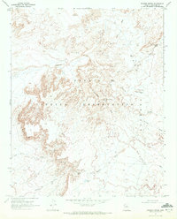
1969 Map of Badger Spring
USGS Topo · Published 1972About this map
The Navajo Indian Reservation landscape is defined by its drainages and dramatic elevation changes, captured here just before the 1970s. The map highlights the critical importance of water in this arid Coconino County terrain, documenting numerous water sources like Little Mexican Spring, Middle Spring, and the namesake Badger Spring. These points of reliable water, along with stock-watering features such as Badger Tank and Beekid Halani Tank, supported a pastoral economy across the open range.
Find a feature on this map
23 named features on this map. Tap any name to fly to it.
Don’t see what you’re looking for? This feature index may not catch every label — zoom into the map to look around manually.
Map Details
Editions of this 1969 Badger Spring Map
This is the sole edition of this map. No revisions or reprints were ever made.
Other maps of this area

1886 · San Francisco Mtns
USGS Topo · 1:250,000

1891 · San Francisco Mtns
USGS Topo · 1:250,000

1894 · San Francisco Mtns
USGS Topo · 1:250,000

1899 · San Francisco Mtns
USGS Topo · 1:250,000

1947 · Flagstaff
USGS Topo · 1:250,000

1954 · Flagstaff
USGS Topo · 1:250,000

1955 · Black Falls 4 SW
USGS Topo · 1:24,000

1955 · Black Falls NE
USGS Topo · 1:24,000
1955 · Cameron SE
USGS Topo · 1:24,000
1955 · Black Falls 4 SE
USGS Topo · 1:24,000