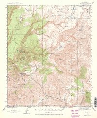
1945 Map of Bagdad
USGS Topo · Published 1973About this map
The settlement of Bagdad serves as a focal point for this mid-1940s landscape, which reveals a rugged high-desert economy driven by intensive mineral extraction. Numerous operations including the Old Dick Mine, Copper King Mine, and Black Pearl Mine are shown throughout the terrain, linked to the town by a network of drainage-following roads like those in Maroney Gulch and Crosby Gulch. The mapping illustrates the reliance on localized water sources in this arid environment, evidenced by dozens of named tanks and springs such as Hardy-Schell Tank, Tod Reese Tank, and Cypress Spr. Beyond the industrial centers, the land transitions into the Prescott National Forest and expansive mesa country, where isolated outposts like Bozarth Ranch and SH Ranch mark the cattle-raising presence in the territory. This survey documents the specific canyon-and-plateau geography of the region before significant modern expansion, highlighting the relationship between the copper-rich geology and the development of local infrastructure.
Find a feature on this map
89 named features on this map. Tap any name to fly to it.
Don’t see what you’re looking for? This feature index may not catch every label — zoom into the map to look around manually.
Map Details
Editions of this 1945 Bagdad Map
3 editions found
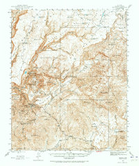
Other maps of this area

1887 · Prescott
USGS Topo · 1:250,000

1892 · Prescott
USGS Topo · 1:250,000

1903 · Congress
USGS Topo · 1:125,000

1904 · Congress
USGS Topo · 1:125,000

1923 · Signal
USGS Topo · 1:250,000

1942 · Signal
USGS Topo · 1:250,000

1945 · Bagdad
USGS Topo · 1:62,500

1947 · Sheridan Mountain
USGS Topo · 1:62,500

1947 · Camp Wood
USGS Topo · 1:62,500

1948 · Sheridan Mountain
USGS Topo · 1:63,360