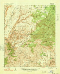
1948 Map of Bagdad
USGS Topo · Published 1948About this map
Mining operations and remote cattle holdings define this high-desert landscape in Yavapai County during the late 1940s. The copper-rich district surrounding Bagdad serves as a primary focal point, anchored by the Hillside Mine and the Comstock Dexter Mine. These industrial sites are interspersed among a network of family-named landmarks like Bozarth Ranch and the SH Ranch, illustrating a transitional period where large-scale mineral extraction operated alongside traditional western ranching.
Find a feature on this map
85 named features on this map. Tap any name to fly to it.
Don’t see what you’re looking for? This feature index may not catch every label — zoom into the map to look around manually.
Map Details
Editions of this 1948 Bagdad Map
2 editions found

Other maps of this area

1887 · Prescott
USGS Topo · 1:250,000

1892 · Prescott
USGS Topo · 1:250,000

1903 · Congress
USGS Topo · 1:125,000

1904 · Congress
USGS Topo · 1:125,000

1923 · Signal
USGS Topo · 1:250,000

1942 · Signal
USGS Topo · 1:250,000

1945 · Bagdad
USGS Topo · 1:62,500

1947 · Sheridan Mountain
USGS Topo · 1:62,500

1947 · Camp Wood
USGS Topo · 1:62,500

1948 · Sheridan Mountain
USGS Topo · 1:63,360