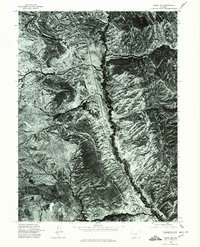
1975 Map of Baggs NW
USGS Topo · Published 1978About this map
Muddy Creek meanders through the heart of this high-altitude Wyoming landscape, cutting a deep path through the arid terrain of the Baggs NW quadrangle. Captured during a 1975 aerial survey by the U.S. Geological Survey, this orthophotoquad provides a stark visual record of the land's complex drainage patterns and geological textures. To the northwest, the seasonal drainage of Robbers Gulch feeds into the larger system, while the elevated region identified as Pines stands out against the surrounding draws. The photographic detail reveals the network of ranch roads and cattle trails that defined Carbon County land use in the mid-1970s, long before modern digital mapping, offering a precise look at the vegetation and soil composition of the high plains.
Find a feature on this map
3 named features on this map. Tap any name to fly to it.
Don’t see what you’re looking for? This feature index may not catch every label — zoom into the map to look around manually.
Map Details
Editions of this 1975 Baggs NW Map
This is the sole edition of this map. No revisions or reprints were ever made.
Other maps of this area

1954 · Rawlins
USGS Topo · 1:250,000

1957 · Baggs
USGS Topo · 1:62,500

1957 · Doty Mountain
USGS Topo · 1:62,500

1958 · Rawlins
USGS Topo · 1:250,000

1962 · Rawlins
USGS Topo · 1:250,000

1967 · Rawlins
USGS Topo · 1:250,000

1970 · Mexican Flats
USGS Topo · 1:24,000
1970 · Flat Top Mountain
USGS Topo · 1:24,000
1970 · Poison Basin
USGS Topo · 1:24,000
1975 · Baggs SW
USGS Topo · 1:24,000