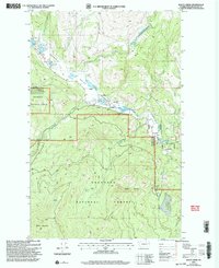
2001 Map of Bailey Creek
USGS Topo · Published 2004About this map
Aeneas Valley serves as a primary geographic focus for this section of the Okanogan National Forest, where the landscape is defined by its complex network of water resources and traditional land divisions. The presence of the Indian Allotment Boundary reflects the historical management of these high-altitude lands, demarcating specific tracts alongside features like a marked Grave and a small Cem near the West Allotment. These cultural markers are positioned between the rugged elevation of Bailey Mountain and the water bodies that dot the terrain, including Ell Lake and Round Lake. The drainage systems are intricate, with Bailey Creek and Cape Labelle Creek feeding into the wider watershed. Remote landmarks such as Squirrel Spring and Bailey Spring provide insight into the localized water sources essential for forest travelers and livestock in this part of Washington.
Find a feature on this map
23 named features on this map. Tap any name to fly to it.
Don’t see what you’re looking for? This feature index may not catch every label — zoom into the map to look around manually.
Map Details
Editions of this 2001 Bailey Creek Map
This is the sole edition of this map. No revisions or reprints were ever made.
Other maps of this area

1902 · Osoyoos
USGS Topo · 1:125,000

1904 · Osoyoos
USGS Topo · 1:125,000

1904 · Republic
USGS Topo · 1:125,000

1951 · Wauconda
USGS Topo · 1:62,500

1952 · Disautel
USGS Topo · 1:62,500

1953 · Bald Knob
USGS Topo · 1:62,500

1954 · Okanogan
USGS Topo · 1:250,000

1957 · Aeneas Valley
USGS Topo · 1:62,500

1958 · Okanogan
USGS Topo · 1:250,000

1958 · Aeneas
USGS Topo · 1:62,500