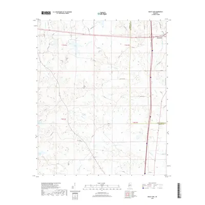
2018 Map of Bailey Lake
USGS Topo · Published 2018About this map
Winona occupies the northeastern corner of this landscape, where the street grid transitions into the winding rural routes of Montgomery and Carroll counties. The terrain is defined by a dense network of tributaries including Little Sand Cr, Powells Cr, and Hurricane Cr, which feed numerous local water bodies such as Bailey Lake and Barrentine Lake. This 2018 survey reveals a countryside shaped by small-scale water management and scattered community anchors.
Find a feature on this map
62 named features on this map. Tap any name to fly to it.
Don’t see what you’re looking for? This feature index may not catch every label — zoom into the map to look around manually.
Map Details
Editions of this 2018 Bailey Lake Map
This is the sole edition of this map. No revisions or reprints were ever made.
Other maps of this area

1953 · West Point
USGS Topo · 1:250,000

1954 · Duck Hill
USGS Topo · 1:62,500

1954 · McCarley
USGS Topo · 1:62,500

1958 · West Point
USGS Topo · 1:250,000

1963 · West Point
USGS Topo · 1:250,000

1966 · Winona
USGS Topo · 1:24,000
1966 · Vaiden
USGS Topo · 1:24,000

1968 · Winona
USGS Topo · 1:62,500
1975 · Peachahala Creek
USGS Topo · 1:24,000
1975 · Murdock Lake
USGS Topo · 1:24,000