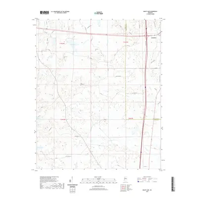
2020 Map of Bailey Lake
USGS Topo · Published 2020About this map
Winona anchors the northeastern corner of this Montgomery County landscape, where the rolling terrain is defined by a dense network of creek drainages and small upland cemeteries. The area south and west of the city transition into a rural expanse marked by several significant burial grounds, including Nebo Cem, Marvin Cem, and Summerfield Cem, which serve as vital markers for local genealogical research. Water features are a prominent part of the geography, with Bailey Lake and Booths Lake situated among the winding paths of Little Sand Cr and Powells Cr. The county line between Carroll and Montgomery counties cuts through the eastern half of the map, illustrating how historical property and political boundaries align with the natural flow of Hays Creek and Hurricane Cr in this portion of North Central Mississippi.
Find a feature on this map
56 named features on this map. Tap any name to fly to it.
Don’t see what you’re looking for? This feature index may not catch every label — zoom into the map to look around manually.
Map Details
Editions of this 2020 Bailey Lake Map
This is the sole edition of this map. No revisions or reprints were ever made.
Other maps of this area

1953 · West Point
USGS Topo · 1:250,000

1954 · Duck Hill
USGS Topo · 1:62,500

1954 · McCarley
USGS Topo · 1:62,500

1958 · West Point
USGS Topo · 1:250,000

1963 · West Point
USGS Topo · 1:250,000

1966 · Winona
USGS Topo · 1:24,000
1966 · Vaiden
USGS Topo · 1:24,000

1968 · Winona
USGS Topo · 1:62,500
1975 · Peachahala Creek
USGS Topo · 1:24,000
1975 · Murdock Lake
USGS Topo · 1:24,000