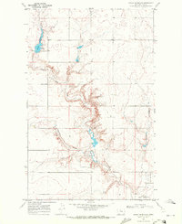
1969 Map of Bailey Reservoir
USGS Topo · Published 1972About this map
Bailey Reservoir dominates the northwestern portion of this northern Montana landscape, its waters contained by a marked Spillway that feeds into the winding course of Sage Creek. The terrain is defined by its drainage patterns, particularly where Halfway Coulee and Schwartz Coulee cut through the high plains toward the south and east. A portion of the Rocky Boys Indian Reservation occupies the southeastern corner, reflecting the complex land management and tribal history of Hill County during the late 1960s. Rural infrastructure is sparse, characterized by scattered Well sites and a single Gravel Pit, suggesting an economy focused on ranching and water management. The survey captures a moment when fence lines and unimproved roads were the primary markers of human activity across these expansive coulees.
Find a feature on this map
8 named features on this map. Tap any name to fly to it.
Don’t see what you’re looking for? This feature index may not catch every label — zoom into the map to look around manually.
Map Details
Editions of this 1969 Bailey Reservoir Map
This is the sole edition of this map. No revisions or reprints were ever made.
Other maps of this area

1904 · Assinniboine
USGS Topo · 1:62,500

1904 · Boxelder
USGS Topo · 1:62,500

1906 · Kremlin
USGS Topo · 1:62,500

1906 · Boxelder
USGS Topo · 1:62,500

1912 · Thibedeau Lake
USGS Topo · 1:125,000

1919 · Big Sandy
USGS Topo · 1:125,000

1920 · Gildford
USGS Topo · 1:125,000

1943 · Gildford
USGS Topo · 1:125,000

1953 · Havre
USGS Topo · 1:250,000

1954 · Shelby
USGS Topo · 1:250,000