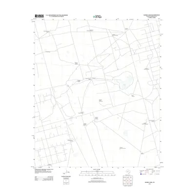
2012 Map of Baird Lake
USGS Topo · Published 2012About this map
Baird Lake sits at the center of this landscape in Andrews County, where the topography is defined by the vital infrastructure of West Texas ranching. The map reveals a highly developed system of water management, evidenced by the numerous numbered and named pumping stations distributed across the grid. Settlements are sparse, represented primarily by C Ranch and a complex network of private access roads and ranch tracks. The naming conventions of the wells, such as Yokle Windmill, Eubanks Windmill, and Red Windmill, provide a genealogical trace of land use and family holdings in this semi-arid region. This 2012 survey captures the intersection of traditional cattle ranching geography with modern energy and resource management, showing how the distribution of water sources like Windmill Number Eightyfour dictates the human footprint on the land.
Find a feature on this map
23 named features on this map. Tap any name to fly to it.
Don’t see what you’re looking for? This feature index may not catch every label — zoom into the map to look around manually.
Map Details
Editions of this 2012 Baird Lake Map
This is the sole edition of this map. No revisions or reprints were ever made.
Other maps of this area

1954 · Hobbs
USGS Topo · 1:250,000

1958 · Hobbs
USGS Topo · 1:250,000

1966 · Mabee Ranch
USGS Topo · 1:24,000

1966 · Bird Ranch
USGS Topo · 1:24,000

1966 · Northwest Midland
USGS Topo · 1:24,000

1968 · Baird Lake
USGS Topo · 1:24,000

1968 · Gardendale NW
USGS Topo · 1:24,000
1968 · Hackberry Lake
USGS Topo · 1:24,000
1968 · Gardendale
USGS Topo · 1:24,000

1971 · Five Wells Ranch SE
USGS Topo · 1:24,000