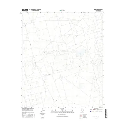
2016 Map of Baird Lake
USGS Topo · Published 2016About this map
Baird Lake sits at the center of this 2016 study of the Andrews County landscape, reflecting the essential role of water catchments in the High Plains environment. The terrain is defined by a network of industrial and rural access routes that speak to the region's petroleum and ranching heritage. Major thoroughfares such as Ranch Rd 1788 intersect with specialized paths like Mabee Oil Rd, illustrating how modern infrastructure has adapted to the extraction-based economy. Secondary roads, including Se 7100 and Se 8000, trace the property boundaries and section lines common to this part of West Texas, providing a clear view of land use and resource management in the early twenty-first century.
Find a feature on this map
5 named features on this map. Tap any name to fly to it.
Don’t see what you’re looking for? This feature index may not catch every label — zoom into the map to look around manually.
Map Details
Editions of this 2016 Baird Lake Map
This is the sole edition of this map. No revisions or reprints were ever made.
Other maps of this area

1954 · Hobbs
USGS Topo · 1:250,000

1958 · Hobbs
USGS Topo · 1:250,000

1966 · Mabee Ranch
USGS Topo · 1:24,000

1966 · Bird Ranch
USGS Topo · 1:24,000

1966 · Northwest Midland
USGS Topo · 1:24,000

1968 · Baird Lake
USGS Topo · 1:24,000

1968 · Gardendale NW
USGS Topo · 1:24,000
1968 · Hackberry Lake
USGS Topo · 1:24,000
1968 · Gardendale
USGS Topo · 1:24,000

1971 · Five Wells Ranch SE
USGS Topo · 1:24,000