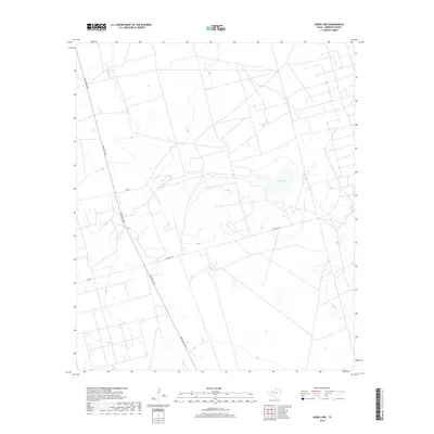
2019 Map of Baird Lake
USGS Topo · Published 2019About this map
Baird Lake lies at the heart of this Andrews County landscape, a seasonal water body surrounded by the expansive terrain of the Permian Basin. This 2019 survey documents the infrastructure of the West Texas oil fields, where a network of utility and service roads such as Mabee Oil Rd, Se 7100, and Se 8000 crisscross the plains to support regional industry. The north-south corridor of Ranch Rd 1788 serves as the primary thoroughfare through this sector, providing a modern reference point for researchers tracing land use and transportation patterns in a region defined by its energy resources and arid geography.
Find a feature on this map
5 named features on this map. Tap any name to fly to it.
Don’t see what you’re looking for? This feature index may not catch every label — zoom into the map to look around manually.
Map Details
Editions of this 2019 Baird Lake Map
This is the sole edition of this map. No revisions or reprints were ever made.
Other maps of this area

1954 · Hobbs
USGS Topo · 1:250,000

1958 · Hobbs
USGS Topo · 1:250,000

1966 · Mabee Ranch
USGS Topo · 1:24,000

1966 · Bird Ranch
USGS Topo · 1:24,000

1966 · Northwest Midland
USGS Topo · 1:24,000

1968 · Baird Lake
USGS Topo · 1:24,000

1968 · Gardendale NW
USGS Topo · 1:24,000
1968 · Hackberry Lake
USGS Topo · 1:24,000
1968 · Gardendale
USGS Topo · 1:24,000

1971 · Five Wells Ranch SE
USGS Topo · 1:24,000