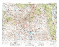
1955 Map of Baker
USGS Topo · Published 1976About this map
Baker and the surrounding high desert and mountain country of eastern Oregon and western Idaho define this mid-century landscape. The Snake River carves a deep path through the center, marked by significant infrastructure including the Oxbow Dam Spillway and Brownlee Dam Spillway. This era shows a region balanced between the historic mining industry, represented by the Flagstaff Mine and Idaho Almaden Mine, and the large-scale water management projects that created the Brownlee Reservoir and Cascade Reservoir.
Find a feature on this map
95 named features on this map. Tap any name to fly to it.
Don’t see what you’re looking for? This feature index may not catch every label — zoom into the map to look around manually.
Map Details
Editions of this 1955 Baker Map
4 editions found

Other maps of this area

1892 · Boise
USGS Topo · 1:125,000

1894 · Squaw Creek
USGS Topo · 1:125,000

1894 · Idaho Basin
USGS Topo · 1:125,000

1897 · Boise
USGS Topo · 1:125,000

1897 · Weiser
USGS Topo · 1:125,000

1898 · Nampa
USGS Topo · 1:125,000

1901 · Baker City
USGS Topo · 1:125,000

1901 · Sumpter
USGS Topo · 1:125,000

1906 · Mitchell Butte
USGS Topo · 1:125,000

1906 · Telocaset
USGS Topo · 1:125,000