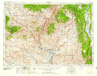
1959 Map of Baker
USGS Topo · Published 1959About this map
The Snake River carves a deep boundary through the center of this mid-century landscape, separating the high peaks of the Wallowa Mountains and Whitman National Forest in Oregon from the Payette National Forest in Idaho. This survey captures a moment when the regional economy relied heavily on the transit corridor provided by the Union Pacific railroad and major highways like U S 30.
Find a feature on this map
57 named features on this map. Tap any name to fly to it.
Don’t see what you’re looking for? This feature index may not catch every label — zoom into the map to look around manually.
Map Details
Editions of this 1959 Baker Map
2 editions found

Other maps of this area

1892 · Boise
USGS Topo · 1:125,000

1894 · Squaw Creek
USGS Topo · 1:125,000

1894 · Idaho Basin
USGS Topo · 1:125,000

1897 · Boise
USGS Topo · 1:125,000

1897 · Weiser
USGS Topo · 1:125,000

1898 · Nampa
USGS Topo · 1:125,000

1901 · Baker City
USGS Topo · 1:125,000

1901 · Sumpter
USGS Topo · 1:125,000

1906 · Mitchell Butte
USGS Topo · 1:125,000

1906 · Telocaset
USGS Topo · 1:125,000