
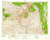
1959 Map of Baker
USGS Topo · Published 1959About this map
The Snake River carves a deep path through the center of this 1950s landscape, marking the border between Oregon and Idaho. On the western side, the Wallowa Mountains and Whitman National Forest dominate the terrain above settlements like Baker and Haines. A legacy of pioneer migration is preserved at the Oregon Trail Memorial Monument near Haines, while the region's industrial past is evident in the presence of the Flagstaff Mine and Virtue Mine.
Find a feature on this map
65 named features on this map. Tap any name to fly to it.
Don’t see what you’re looking for? This feature index may not catch every label — zoom into the map to look around manually.
Map Details
Editions of this 1959 Baker Map
2 editions found
Other maps of this area

1892 · Boise
USGS Topo · 1:125,000

1894 · Squaw Creek
USGS Topo · 1:125,000

1894 · Idaho Basin
USGS Topo · 1:125,000

1897 · Boise
USGS Topo · 1:125,000

1897 · Weiser
USGS Topo · 1:125,000

1898 · Nampa
USGS Topo · 1:125,000

1901 · Baker City
USGS Topo · 1:125,000

1901 · Sumpter
USGS Topo · 1:125,000

1906 · Mitchell Butte
USGS Topo · 1:125,000

1906 · Telocaset
USGS Topo · 1:125,000