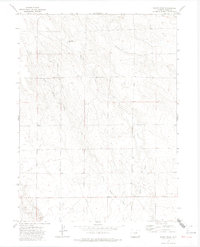
1972 Map of Baker Draw
USGS Topo · Published 1974About this map
Baker Draw and its network of ephemeral drainage channels characterize this high-plains landscape in Weld County. This 1972 survey documents an era of resource management and water storage in a semi-arid region, evidenced by Sand Res No 1 and Sand Res No 2. The terrain is defined by the convergence of several small waterways, including Howard Creek, Little Sand Creek, and Sand Creek, which carve subtle depressions through the prairie. Industrial infrastructure is present in the form of a major north-south Pipeline, while the presence of scattered Well sites suggests local ranching or agricultural operations. The map provides a look at the section-line roads and cadastral boundaries typical of this Colorado-Wyoming borderland before modern development altered the rural character of the northern plains.
Find a feature on this map
10 named features on this map. Tap any name to fly to it.
Don’t see what you’re looking for? This feature index may not catch every label — zoom into the map to look around manually.
Map Details
Editions of this 1972 Baker Draw Map
2 editions found
Other maps of this area

1908 · Eaton
USGS Topo · 1:125,000

1910 · Eaton
USGS Topo · 1:125,000

1954 · Greeley
USGS Topo · 1:250,000

1957 · Greeley
USGS Topo · 1:250,000

1958 · Greeley
USGS Topo · 1:250,000

1960 · Purcell
USGS Topo · 1:24,000
1960 · Galeton
USGS Topo · 1:24,000

1961 · Greeley
USGS Topo · 1:250,000

1964 · Greeley
USGS Topo · 1:250,000

1965 · Greeley
USGS Topo · 1:250,000