
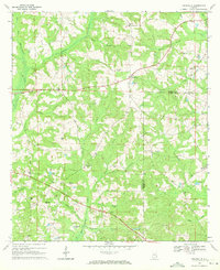
1968 Map of Baker Hill
USGS Topo · Published 1970About this map
The Old Indian Treaty Boundary slices diagonally across this Barbour County landscape, serving as a historical marker in a region defined by its creek-fed bottomlands. Small settlements such as Baker Hill and Gains anchor the local road network, while the rural character is emphasized by numerous country churches and family-named landmarks. The terrain is deeply carved by the East Fork Choctawhatchee River and Cheneyhatchee Creek, creating a complex drainage system that supported small-scale agriculture and early industry like Williams Millpond. Evidence of extractive activity is visible in the clusters of quarries near Oateston, while genealogy interests are well-served by the mapping of several isolated cemeteries, including Scotch Cem and Walker Cem. From the banks of South Chipola Creek to the upland ridge at Cotton Hill, the map documents a traditional Alabama agricultural community in the late 1960s.
Find a feature on this map
34 named features on this map. Tap any name to fly to it.
Don’t see what you’re looking for? This feature index may not catch every label — zoom into the map to look around manually.
Map Details
Editions of this 1968 Baker Hill Map
This is the sole edition of this map. No revisions or reprints were ever made.
Other maps of this area

1953 · Dothan
USGS Topo · 1:250,000

1954 · Dothan
USGS Topo · 1:250,000

1955 · Dothan
USGS Topo · 1:250,000

1967 · Clayton South
USGS Topo · 1:24,000

1968 · Eufaula North
USGS Topo · 1:24,000

1968 · White Oak
USGS Topo · 1:24,000

1968 · Clayton North
USGS Topo · 1:24,000

1968 · Eufaula South
USGS Topo · 1:24,000

1969 · Fort Gaines NW
USGS Topo · 1:24,000
1969 · Texasville
USGS Topo · 1:24,000