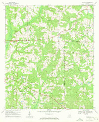
1969 Map of Texasville
USGS Topo · Published 1971About this map
Texasville and the surrounding rural landscape of the Barbour and Henry county line are characterized by a dense network of country churches and small family-named landmarks. The terrain is defined by the winding course of the West Fork Choctawhatchee River and numerous tributaries such as Lindsey Creek and Beaver Creek. Evidence of local community life is scattered throughout the hills, from the Blue Springs Sch in the west to the tiny settlement of Edwin in the east. Numerous religious centers, including St Peters Ch, Adams Chapel, and Triumph Ch, serve as focal points for the dispersed population. Topographical features like Shipes Hill and Medley Hill rise above the wetlands of Spencers Pond and Lingo Pond, while the Radio Tower (WGIQ) stands as a modern marker in the agricultural heartland during the late 1960s.
Find a feature on this map
48 named features on this map. Tap any name to fly to it.
Don’t see what you’re looking for? This feature index may not catch every label — zoom into the map to look around manually.
Map Details
Editions of this 1969 Texasville Map
This is the sole edition of this map. No revisions or reprints were ever made.
Other maps of this area

1953 · Dothan
USGS Topo · 1:250,000

1954 · Dothan
USGS Topo · 1:250,000

1955 · Dothan
USGS Topo · 1:250,000

1967 · Clayton South
USGS Topo · 1:24,000

1968 · Baker Hill
USGS Topo · 1:24,000

1968 · Louisville
USGS Topo · 1:24,000

1969 · Abbeville West
USGS Topo · 1:24,000
1969 · Clio
USGS Topo · 1:24,000
1969 · Skipperville
USGS Topo · 1:24,000
1969 · Clopton
USGS Topo · 1:24,000