
1968 Map of Eufaula South
USGS Topo · Published 1970About this map
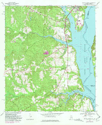
Walter F George Reservoir dominates the eastern edge of this Alabama-Georgia borderland, where the Chattahoochee River broadens significantly against the shoreline of Eufaula. The landscape is defined by the transition from river commerce to the upland interior, evidenced by the Chauncey Sparks Terminal and the nearby Chauncey Sparks Trade Sch. Further inland, the terrain is marked by historical boundary lines and rural community centers. The Old Indian Treaty Bdy cuts diagonally across the southern half of the map, a significant historical marker for land titles and genealogy. Rural life is anchored by local institutions such as Bluff City Sch, Epworth Ch, and Sardis Ch, while the creeks like Cheneyhatchee Creek and White Oak Creek feed into the reservoir, providing recreational space at the Cheneyhatchee Creek Recreation Area.
Find a feature on this map
31 named features on this map. Tap any name to fly to it.
Don’t see what you’re looking for? This feature index may not catch every label — zoom into the map to look around manually.
Map Details
Editions of this 1968 Eufaula South Map
2 editions found
Other maps of this area

1953 · Dothan
USGS Topo · 1:250,000

1954 · Dothan
USGS Topo · 1:250,000

1955 · Dothan
USGS Topo · 1:250,000

1967 · Hatcher
USGS Topo · 1:24,000

1967 · Georgetown
USGS Topo · 1:24,000

1968 · Eufaula North
USGS Topo · 1:24,000

1968 · Baker Hill
USGS Topo · 1:24,000

1968 · White Oak
USGS Topo · 1:24,000

1969 · Fort Gaines NW
USGS Topo · 1:24,000

1969 · Fort Gaines NE
USGS Topo · 1:24,000