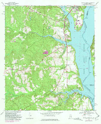
1968 Map of Eufaula South
USGS Topo · Published 1981About this map
Eufaula sits at the edge of the Walter F George Reservoir in this late 1960s survey, updated with late 1970s aerial photography. The landscape is defined by the transition from the city’s industrial and educational sites, like the Chauncey Sparks Terminal and Chauncey Sparks Trade Sch, to the rural hinterlands of Barbour County. A significant historical line, the Old Indian Treaty Bdy, cuts diagonally across the southwestern portion of the sheet, marking a legacy of early territorial division.
Find a feature on this map
36 named features on this map. Tap any name to fly to it.
Don’t see what you’re looking for? This feature index may not catch every label — zoom into the map to look around manually.
Map Details
Editions of this 1968 Eufaula South Map
2 editions found
Other maps of this area

1953 · Dothan
USGS Topo · 1:250,000

1954 · Dothan
USGS Topo · 1:250,000

1955 · Dothan
USGS Topo · 1:250,000

1967 · Hatcher
USGS Topo · 1:24,000

1967 · Georgetown
USGS Topo · 1:24,000

1968 · Eufaula North
USGS Topo · 1:24,000

1968 · Baker Hill
USGS Topo · 1:24,000

1968 · White Oak
USGS Topo · 1:24,000

1968 · Eufaula South
USGS Topo · 1:24,000

1969 · Fort Gaines NW
USGS Topo · 1:24,000