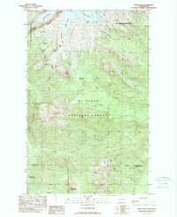
1989 Map of Baker Pass
USGS Topo · Published 1989About this map
Deming Glacier and Easton Glacier dominate the northern landscape of this 1980s survey, marking a terrain defined by ice and volcanic geology. The map documents a complex system of glacial features including the Metcalfe Moraine and Sulphur Moraine, which feed the headwaters of the Middle Fork Nooksack River. A prominent Lookout Tower sits atop Park Butte, overlooking the high-altitude transit of Baker Pass and the distinctive Railroad Grade trail. Further south, the terrain transitions into the heavily forested slopes of Mt Baker National Forest, where features like Schriebers Meadow and Loomis Mtn stand near the boundary line between Whatcom and Skagit counties. The survey also identifies isolated landmarks such as the Washington Monument and Dock Butte, reflecting the nomenclature of late-20th-century wilderness management.
Find a feature on this map
42 named features on this map. Tap any name to fly to it.
Don’t see what you’re looking for? This feature index may not catch every label — zoom into the map to look around manually.
Map Details
Editions of this 1989 Baker Pass Map
2 editions found
Other maps of this area

1909 · Mt Baker
USGS Topo · 1:192,000

1915 · Mt. Baker
USGS Topo · 1:250,000

1952 · Lake Shannon
USGS Topo · 1:62,500

1952 · Mt. Baker
USGS Topo · 1:62,500

1952 · Hamilton
USGS Topo · 1:62,500

1953 · Mt Shuksan
USGS Topo · 1:62,500

1955 · Concrete
USGS Topo · 1:250,000

1958 · Concrete
USGS Topo · 1:250,000

1962 · Concrete
USGS Topo · 1:250,000
1973 · Hamilton
USGS Topo · 1:62,500