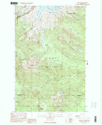
1989 Map of Baker Pass
USGS Topo · Published 1989About this map
The Mt Baker Wilderness and Mt Baker National Forest dominate this landscape where Whatcom and Skagit counties meet. Glacial activity is the primary architect of the terrain, visible in the massive ice sheets of Deming Glacier, Easton Glacier, and Squak Glacier. These icy reaches feed a network of water systems, including the Middle Fork Nooksack River and the South Fork Nooksack River.
Find a feature on this map
40 named features on this map. Tap any name to fly to it.
Don’t see what you’re looking for? This feature index may not catch every label — zoom into the map to look around manually.
Map Details
Editions of this 1989 Baker Pass Map
2 editions found
Other maps of this area

1909 · Mt Baker
USGS Topo · 1:192,000

1915 · Mt. Baker
USGS Topo · 1:250,000

1952 · Lake Shannon
USGS Topo · 1:62,500

1952 · Mt. Baker
USGS Topo · 1:62,500

1952 · Hamilton
USGS Topo · 1:62,500

1953 · Mt Shuksan
USGS Topo · 1:62,500

1955 · Concrete
USGS Topo · 1:250,000

1958 · Concrete
USGS Topo · 1:250,000

1962 · Concrete
USGS Topo · 1:250,000
1973 · Hamilton
USGS Topo · 1:62,500