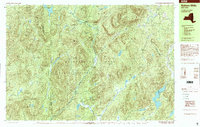
1997 Map of Bakers Mills
USGS Topo · Published 2000About this map
The East Branch Sacandaga River carves through this late-twentieth-century landscape, defining a region where the wild and the settled intersect within the Adirondack Park. The small community of Bakers Mills serves as a focal point near the northeastern corner, while the interior is dominated by the State Forest Preserve. The map reveals a history of backcountry utility and migration, noted by features like Burnt Shanty Clearing and Curtis Clearing. For genealogists and local historians, specific markers such as Grave and Graves near the settlements provide small but significant points of family history. The topography is characterized by prominent peaks including Eleventh Mountain and Big Shanty Mtn, while a network of water bodies like Garnet Lake and Siamese Ponds suggests a landscape shaped by both natural drainage and recreational use, underscored by the presence of a Snowmobile Trail.
Find a feature on this map
71 named features on this map. Tap any name to fly to it.
Don’t see what you’re looking for? This feature index may not catch every label — zoom into the map to look around manually.
Map Details
Editions of this 1997 Bakers Mills Map
This is the sole edition of this map. No revisions or reprints were ever made.
Other maps of this area

1895 · North Creek
USGS Topo · 1:62,500

1897 · North Creek
USGS Topo · 1:62,500

1898 · Thirteenth Lake
USGS Topo · 1:62,500

1899 · Indian Lake
USGS Topo · 1:62,500

1902 · Indian Lake
USGS Topo · 1:62,500

1903 · Luzerne
USGS Topo · 1:62,500

1907 · Lake Pleasant
USGS Topo · 1:62,500

1910 · Stony Creek
USGS Topo · 1:62,500

1950 · Glens Falls
USGS Topo · 1:250,000

1950 · Utica
USGS Topo · 1:250,000