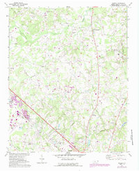
1971 Map of Bakers
USGS Topo · Published 1987About this map
Bakers and the surrounding Union County landscape are defined by a dense network of rural congregation points and family-linked waterways. Numerous churches, including Shiloh Ch, Sardis Ch, and Morning Star Ch, anchor the small settlements of Unionville and Bentons Crossroads. The terrain is deeply etched by the upper reaches of Goose Creek and Crooked Creek, with smaller tributaries like Stumpy Branch and Lick Fork carving through the Piedmont hills. This era shows the encroaching modern infrastructure of Monroe from the south, including the Monroe Airport and the Fairgrounds, while the CSX railroad corridor cuts a diagonal path toward the Bakers community. The map captures a moment of transition where traditional agrarian crossroads begin to integrate with suburban expansions like the Rolling Hills Country Club.
Find a feature on this map
47 named features on this map. Tap any name to fly to it.
Don’t see what you’re looking for? This feature index may not catch every label — zoom into the map to look around manually.
Map Details
Editions of this 1971 Bakers Map
3 editions found
Other maps of this area

1941 · Charlotte
USGS Topo · 1:125,000

1941 · Spartanburg
USGS Topo · 1:250,000

1942 · Charlotte
USGS Topo · 1:125,000

1949 · Wilgrove
USGS Topo · 1:24,000

1949 · Midland
USGS Topo · 1:24,000

1953 · Spartanburg
USGS Topo · 1:250,000

1953 · Charlotte
USGS Topo · 1:250,000

1954 · Charlotte
USGS Topo · 1:250,000

1960 · Charlotte
USGS Topo · 1:250,000

1960 · Spartanburg
USGS Topo · 1:250,000