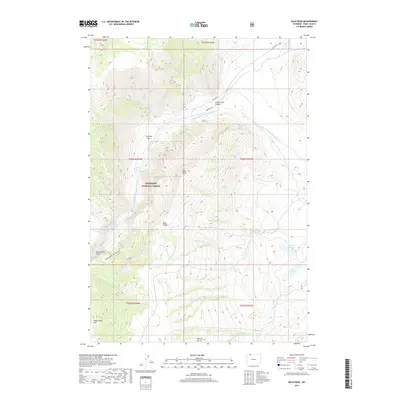
2017 Map of Bald Peak
USGS Topo · Published 2017About this map
The Clarks Fork Yellowstone River carves a deep path through this section of the Shoshone National Forest, creating the dramatic Clarks Fork Canyon. The topography is defined by high-altitude features like Bald Peak and Bald Ridge, while the water system includes both natural features like Bridal Veil Falls and man-made infrastructure such as Hogan Reservoir and Luce Reservoir. Transportation in this high-country landscape is limited to a few specific corridors, including Canyon Rd, Morrison Rd, and the Dead Indian Gulch Trail. A notable landform known as the Natural Corral and the flat expanse of Cyclone Bar reflect the diverse geologic history of Park County. The map provides a detailed look at the drainage patterns of Newmeyer Cr and Dead Indian Gulch as they descend toward the river valley.
Find a feature on this map
27 named features on this map. Tap any name to fly to it.
Don’t see what you’re looking for? This feature index may not catch every label — zoom into the map to look around manually.
Map Details
Editions of this 2017 Bald Peak Map
This is the sole edition of this map. No revisions or reprints were ever made.
Other maps of this area

1949 · Pat O'Hara Mountain
USGS Topo · 1:62,500

1949 · Cody
USGS Topo · 1:62,500

1950 · Clark
USGS Topo · 1:62,500

1950 · Deep Lake
USGS Topo · 1:62,500

1951 · Cody
USGS Topo · 1:62,500

1955 · Cody
USGS Topo · 1:250,000

1958 · Cody
USGS Topo · 1:250,000

1962 · Cody
USGS Topo · 1:250,000

1980 · Cody
USGS Topo · 1:100,000
1987 · Dead Indian Meadows
USGS Topo · 1:24,000